A waymarked prehistoric trail in Westerkirk and Eskdalemuir, conveniently accessible to motorists or cyclists with a modest amount of walking, linking several prehistoric sites of outstanding archaeological interest.
Peering into the Past
To get the best out of this waymarked trail, you can either print out the information from this site or get the free Trail Leaflet obtainable from nearby Visitor Information points, including the Buccleuch Centre, Langholm. Once you are on the Trail there are brown tourist signs and marker posts with our logo at each site.
Interpretation Panels
There are interpretation panels at each site.
Boxes attached to the panel posts contain laminated information sheets with site plans (reproduced by kind permission of RCAHMS) where appropriate. These plans are referred to in the site descriptions on these web pages and can be accessed on the Canmore section of the RCAHMS website. Registration is free.
OS Explorer 323 is helpful, and tough waterproof boots/shoes are essential.
Our ancestors wanted their strongholds to be readily defended, so the approaches are usually steep. Some parts of the Trail can’t be recommended for those with serious mobility problems. YOUR VISIT IS AT YOUR OWN RISK
Please note: Bessie’s Hill section of the Prehistoric Trail that will be closed for 3 months from 30th September 2023 due to the clearance of Windblown trees.
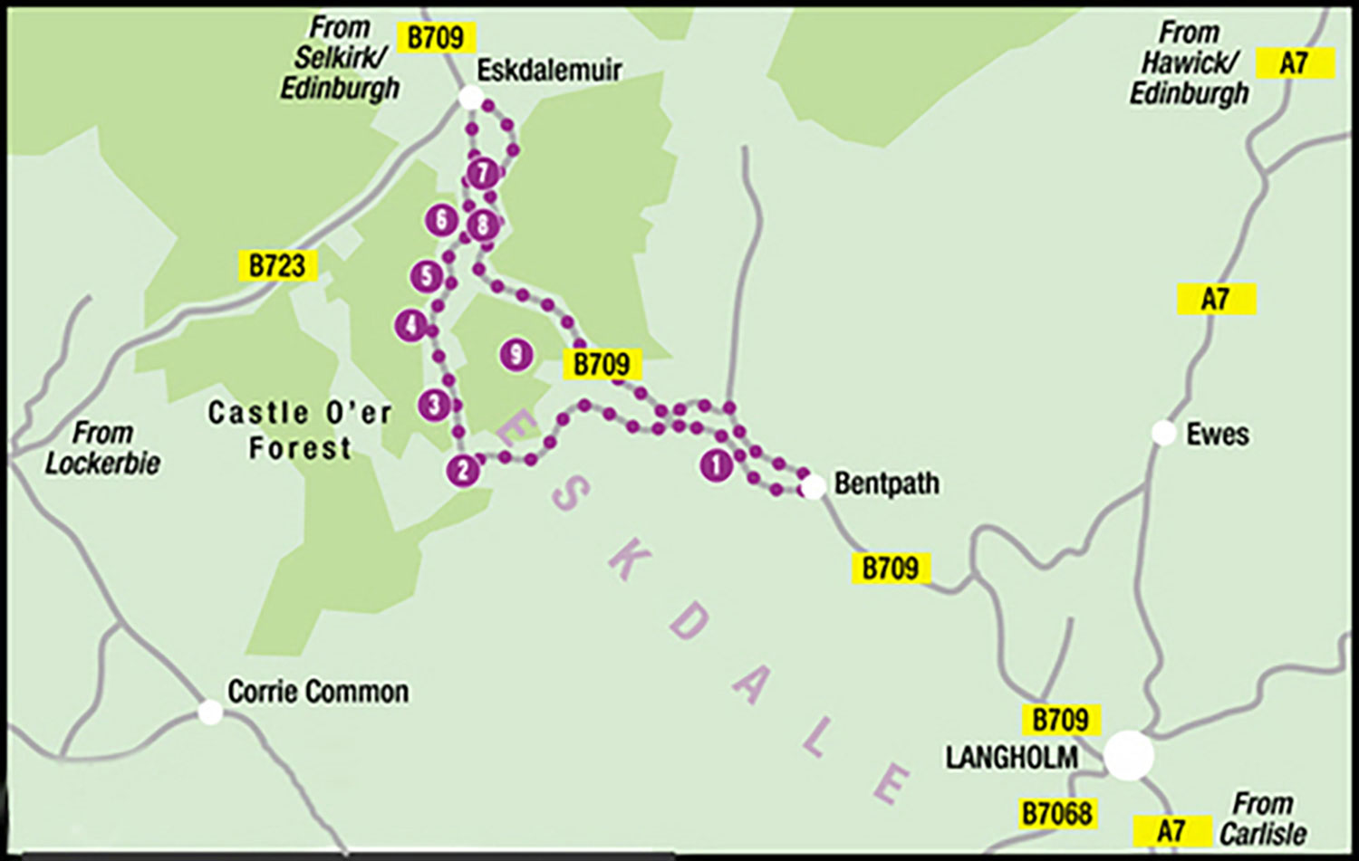
The Prehistoric Trials:
1. Boonies: A Romano-British farmstead
2. Bailiehill: A Magnificent hill citadel
3. The Knowe: A fortlet, farm or fortified croft
4. Castle O’er: The most superb of the Esk Valley hill forts
5. Over Rig: A unique and perplexing site – fascinating but mysterious
6. Bessie’s Hill: A fort and enclosure
7. The Loupin’ Stanes: A small but impressive stone ring
8. The Girdle Stanes: A large stone ring
9. King Schaw’s Grave: A burial kist, once buried under a vast cairn
The Inspiration came from a series of lectures given in Langholm in the 1970s by the distinguished archaeologist Dr Lionel Masters, then Director of Extramural Studies for Dumfries and Galloway. He organized a field trip to Westerkirk and Eskdalemuir one memorably pleasant Sunday afternoon, taking in most of the sites on our trail. The notion of a formal Trail lay dormant for too many years, but was revived in the 2000s when the Langholm Cultural and Heritage Committee was formed.
The Idea was to outline and waymark a trail in Westerkirk and Eskdalemuir, accessible to motorists or cyclists who were prepared to do a modest amount of walking, linking several prehistoric sites of outstanding archaeological interest.
The Artists
Members of Langholm and District Art Club – Margaret Hobson, Dick Irving, Tom Kennedy and Jean Weatherstone – prepared paintings for the interpretation panels, based on advice from available texts and from the Regional Archaeologist, Jane Brann. Their paintings make a strong local statement.
Support with funds, Information and know-how
We are grateful to the landowners for welcoming the Trail:
- Stewart and Sarah Pool
- The Tanlawhill Estate
- Forest Enterprise
- Tilhill Forestry
The trail was prepared by Langholm Initiative working together with Making Tracks (green tourism).
Financial support and advice were received from:
- Annandale and Eskdale Council
- The Andrew Stevenson Foundation
- The Arthur Bell Trust
- Kagyu Samye Ling
- Langholm Initiative
- Scottish Natural Heritage
- Solway Heritage (who with Archaeosights did the signing for four of the sites on the Trail)
Above all we’re grateful to the people of Westerkirk and Eskdalemuir for welcoming the Trail.
Getting Going
To get the best out of this waymarked trail, you can either print out the information from this site or get the free Trail Leaflet obtainable from nearby Visitor Information points, including the Buccleuch Centre, Langholm. Once you are on the Trail there are brown tourist signs and marker posts with our logo at each site.
Our ancestors wanted their strongholds to be readily defended, so the approaches are usually steep. Some parts of the Trail can’t be recommended for those with serious mobility problems. YOUR VISIT IS AT YOUR OWN RISK.
This website text may contain errors of omission or commission and of fact, of interpretation or of emphasis.